Error message
Notice: Trying to access array offset on value of type null in IslandoraSolrDisplayManagerResults->currentQueryDisplays() (line 222 of /var/www/drupal7/sites/all/modules/islandora_solr_display_manager/includes/islandora_solr_display_manager.inc).
-
-
Title
-
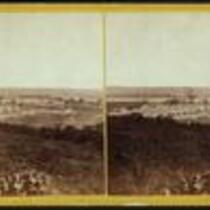
Fort Leavenworth, Kansas
-
Description
-
Stereograph of Fort Leavenworth, Kansas, from 1867. Fort Leavenworth was originally established in 1827 to provide protection along the Santa Fe Trail. During the Civil War, Fort Leavenworth served as a training station for Kansas volunteers, and in 1864 the fort's garrison prepared for a possible attack by Major General Sterling Price on his Missouri Expedition. At an age of more than 180 years, Fort Leavenworth is the oldest post west of Washington, D.C. that remains in continuous operation.
-
Object Type
-
Image
-
Date
-
1867
-
-
Title
-
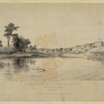
Leavenworth City, Kansas Territory
-
Description
-
Depiction of the city of Leavenworth, Kansas in 1856. Missourians from Weston, Missouri and residents of Fort Leavenworth founded the city in the fall of 1854.
-
Object Type
-
Image
-
Date
-
n.d.
-
-
Title
-
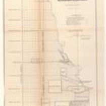
Plan of the Public Surveys in Kansas and Nebraska
-
Description
-
This black-and-white map, signed by J. Calhoun, Surveyor General of Kansas and Nebraska, was issued by the Surveyor General’s office in Wyandott, Kansas Territory on October 20, 1856. The map is entitled "Plan of the Public Surveys in Kansas and Nebraska." It was printed by Ackerman Lithographers in New York.
-
Object Type
-
Map
-
Date
-
October 20, 1856
-

-
Title
-
Sectional Map of the Territory of Kansas
-
Description
-
This color map, entitled “Sectional Map of the Territory of Kansas,” was compiled from the field notes in the Surveyor General’s office. It was published in 1857 by John Halsall in St. Louis.
-
Object Type
-
Map
-
Date
-
1857
-

-
Title
-
Kansas and Nebraska 1856
-
Description
-
This color map, entitled “Kansas and Nebraska 1856,” was printed by J.G. Wells in New York.
-
Object Type
-
Map
-
Date
-
1856
-

-
Title
-
Sketch of the Public Surveys in Kansas and Nebraska
-
Description
-
This black-and-white map, signed by J. Calhoun, Surveyor General, was issued by the Surveyor General’s office in Wyandott, Kansas Territory on November 8, 1856. The map is entitled “Sketch of the Public Surveys in Kansas and Nebraska.” It was printed by A. Hoen and Co. in Baltimore.
-
Object Type
-
Map
-
Date
-
November 8, 1855
-

-
Title
-
Map Depicting the Western Territory
-
Description
-
This undated black-and-white map depicts the Western territory between Fort Leavenworth, Kansas, and the Rocky Mountains. The map shows rivers, Indian territories, villages, and other points of interest. A dotted line indicates the route taken by U.S. dragoons in 1835 under the command of Col. Dodge.
