Error message
Notice: Trying to access array offset on value of type null in IslandoraSolrDisplayManagerResults->currentQueryDisplays() (line 222 of /var/www/drupal7/sites/all/modules/islandora_solr_display_manager/includes/islandora_solr_display_manager.inc).
Pages
-
-
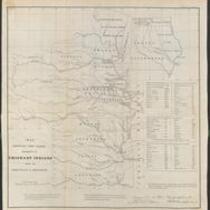
Title
-
Delaware Indians
-
Description
-
Photograph of Delaware Indians, ca. 1860-1865.
-
Object Type
-
Image
-
-
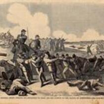
Title
-
Battle of Wilson's Creek
-
Description
-
This sketch, originally published in Harper's Weekly on August 31, 1861, depicts the Union retreat at the end of the Battle of Wilson's Creek on August 10, 1861, after Nathaniel Lyon's death and after Sigel's horses had been killed. The caption states: "General Siegel forcing his prisoners [Confederate and Native American] to draw off his cannon at the Battle of Springfield." Although Harper's Weekly describes this as the Battle of Springfield, this conflict has come to be known as the Battle of Wilson's Creek. The next skirmish in the area, Zagonyi's Charge, occured near Springfield, Missouri on October 25, 1861.
-
Object Type
-
Image
-
Date
-
August 31, 1861
-

-
Title
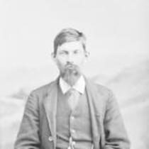
-
Mr. John Harris
-
Description
-
Carte de visite portrait of Sergeant John Harris, member of the 10th United States Cavalry Regiment. The 10th Cavalry and other black regiments (including the 9th Cavalry, the 24th Infantry, and the 25th Infantry) acquired the nickname of "Buffalo Soldiers" as a result of their exploits during the Indian Wars.
-
Object Type
-
Image
-

-
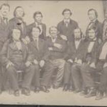
Title
-
Charles Bluejacket
-
Description
-
Photograph of Charles Bluejacket (1816-1897), Kansas member of the Shawnee Tribe. This is found in the 1906 publication of "Transactions of the Kansas Historical Society: Vol. IX.".
-
Object Type
-
Image
-
Date
-
n.d.
-
-
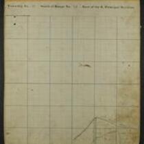
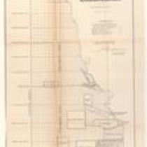
Title
-
Maps of Shawnee Indian Reservation
-
Description
-
These 21 plat maps were made ca. 1857 by Isaac Cooper Stuck. The maps are marked with geographical features and locations of people’s land claims within the Shawnee Indian Reservation in eastern Kansas.
-
Object Type
-
Map
-
![Constitutional Convention, Topeka, Kansas Territory [Topeka]](https://civilwaronthewesternborder.org/sites/civilwaronthewesternborder.org/files/styles/islandora_imagecache_image_style_medium/public/externals/be261c1645001f328b7032d00e8de879.jpg?itok=o4Mdz8vY&pid=civilwar:1311&iic=true)
-
Title
-
Constitutional Convention, Topeka, Kansas Territory [Topeka]
-
Description
-
Wood engraving depicting the Topeka Constitutional Convention of December 15, 1855. At the convention, Free-Staters voted to adopt the Topeka Constitution for Kansas Territory, provisionally banning slavery in Kansas and allowing suffrage for "civilized" male Native Americans, but still excluded blacks from settling in the state. However, the constitution failed to gain the recognition of proslavery settlers and the federal government, including President Franklin Pierce, who declared the Topeka legislature to be illegal and treasonous.
-
Object Type
-
Image
-
Date
-
December 15, 1855
-
-
Title
-
Plan of the Public Surveys in Kansas and Nebraska
-
Description
-
This black-and-white map, signed by J. Calhoun, Surveyor General of Kansas and Nebraska, was issued by the Surveyor General’s office in Wyandott, Kansas Territory on October 20, 1856. The map is entitled "Plan of the Public Surveys in Kansas and Nebraska." It was printed by Ackerman Lithographers in New York.
-
Object Type
-
Map
-
Date
-
October 20, 1856
-

-
Title
-
Sectional Map of Kansas Territory
-
Description
-
This color map, dated April 1857, is entitled "Sectional Map of Kansas Territory." It was drafted by C.P. Wiggin and signed by L.A. MacLean, Chief Clerk of the Surveyor General’s office in Lecompton, Kansas Territory. MacLean certifies that the map was compiled from U.S. survey field notes. The map was published by MacLean and Lawrence and printed by William Schuchman and Bro. in Philadelphia.
-
Object Type
-
Map
-
Date
-
April 1857
-

-
Title
-
Nebraska and Kanzas
-
Description
-
This color map, ca. 1854-1861, is entitled “Nebraska and Kanzas.” It was printed by J.H. Colton and Co. in New York.
-
Object Type
-
Map
-
Date
-
1854-1861
-

-
Title
-
New Sectional Map of Kansas
-
Description
-
This color map, drafted in 1859 by Robert L. Ream, was published by Stevenson and Morris of St. Louis, and printed by A. Janicke and Co. of St. Louis. The map is entitled “New Sectional Map of Kansas,” and was compiled from the field notes in the Surveyor General’s office.
-
Object Type
-
Map
-
Date
-
1859
-

-
Title
-
Sectional Map of the Territory of Kansas
-
Description
-
This color map, entitled “Sectional Map of the Territory of Kansas,” was compiled from the field notes in the Surveyor General’s office. It was published in 1857 by John Halsall in St. Louis.
-
Object Type
-
Map
-
Date
-
1857
-

-
Title
-
Map Showing the Progress of the Public Surveys in the Territories of Kansas and Nebraska
-
Description
-
This black-and-white map, signed by Ward B. Burnett, Surveyor General, was issued by the Surveyor General’s office in Nebraska City, Nebraska Territory on October 1, 1860. The map shows the progress of the public surveys in the territories of Kansas and Nebraska, and was produced to accompany the Surveyor General’s 1860 annual report.
-
Object Type
-
Map
-
Date
-
October 1, 1860
-

-
Title
-
Map Showing the Progress of the Public Surveys in the Territories of Kansas and Nebraska
-
Description
-
This black-and-white map, signed by Ward B. Burnett, Surveyor General, was issued by the Surveyor General’s office in Nebraska City, Nebraska Territory on October 1, 1859. The map shows the progress of the public surveys in the territories of Kansas and Nebraska, and was produced to accompany the Surveyor General’s 1859 annual report.
-
Object Type
-
Map
-
Date
-
October 1, 1859
-

-
Title
-
Map Showing the Progress of the Public Surveys in Kansas and Nebraska
-
Description
-
This black-and-white map, signed by Mark W. Delahay, Surveyor General, was issued by the Surveyor General’s office in Leavenworth, Kansas on September 2, 1861. The map shows the progress of the public surveys in Kansas and Nebraska, and was produced to accompany the Surveyor General’s report of 1861.
-
Object Type
-
Map
-
Date
-
September 2, 1861
-

-
Title
-
Sketch of the Public Surveys in Kansas and Nebraska
-
Description
-
This black-and-white map, signed by J. Calhoun, Surveyor General, was issued by the Surveyor General’s office in Wyandott, Kansas Territory on November 8, 1856. The map is entitled “Sketch of the Public Surveys in Kansas and Nebraska.” It was printed by A. Hoen and Co. in Baltimore.
-
Object Type
-
Map
-
Date
-
November 8, 1855
-

-
Title
-
Map Showing the Progress of the Public Surveys in the Territories of Kansas and Nebraska
-
Description
-
This black-and-white map, signed by Ward B. Burnett, Surveyor General, was issued by the Surveyor General’s office in Nebraska City, Nebraska Territory on October 1, 1858. The map depicts the progress of the public surveys in Kansas and Nebraska in 1858, and was created to accompany the Surveyor General's report of that year. The map was printed by C.B. Graham Lithographers in Washington, DC.
-
Date
-
October 1, 1858
-

-
Title
-
Map Showing the Progress of the Public Surveys in the Territories of Kansas and Nebraska
-
Description
-
This black-and-white map, signed by J. Calhoun, Surveyor General, was issued by the Surveyor General’s office in Lecompton, Kansas Territory in October 1857. The map shows the progress of the public surveys in the territories of Kansas and Nebraska, and was produced to accompany the Surveyor General’s 1857 annual report.
-
Date
-
October 1857
Pages