Error message
Notice: Trying to access array offset on value of type null in IslandoraSolrDisplayManagerResults->currentQueryDisplays() (line 222 of /var/www/drupal7/sites/all/modules/islandora_solr_display_manager/includes/islandora_solr_display_manager.inc).
-
-
Title
-
Medical Record of Examination of Recruits
-
Description
-
This is a bound volume of records noting the medical examinations of men recruited to the Union Army in Kansas. The records, dating from November 5, 1864 to April 20, 1865, include the recruits' names, ages, country or state of birth, occupation, height, complexion, eye and hair color, chest measurements, race, and town or county of residence.
-
Date
-
November 5, 1864-April 20, 1865
-
-
Title
-
From G.W. Veale to George W. Dietzler
-
Description
-
On October 30, 1864, this dispatch was sent by Col. G.W. Veale at Headquarters, 2nd Regiment, Kansas State Militia in Topeka, Kansas, to Maj. Gen. Dietzler, Comm. Kansas State Militia. Veale reports on a recent campaign in which his regiment moved from Topeka to Shawneetown in Johnson County, Kansas, to Jackson County, Missouri, where it fought in the Battle of the Blue on October 22, 1864. Veale states that his regiment lost 44 killed and wounded, with 68 men taken prisoner after fighting “a force six times our number for three quarters of an hour.” The dispatch includes a list of the soldiers killed and wounded in the battle.
-
Date
-
October 30, 1864
-
-
Title
-
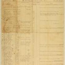
Muster Rolls of Kansas Volunteer Regiments
-
Description
-
These muster rolls from 1861 and 1862 list the names, ranks, and enrollment dates of soldiers in companies from the 4th and 10th Kansas Volunteer Regiments. They also list the names of soldiers who deserted their regiments or were discharged, transferred, or deceased. The companies were commanded by Capt. James M. Harvey, Capt. James H. Harris, Col. William Weir, and Col. William Cloud.
-
Date
-
1861-1862
-

-
Title
-
Map Showing the Progress of the Public Surveys in Kansas and Nebraska
-
Description
-
This black-and-white map, signed by Mark W. Delahay, Surveyor General, was issued by the Surveyor General’s office in Leavenworth, Kansas on September 2, 1861. The map shows the progress of the public surveys in Kansas and Nebraska, and was produced to accompany the Surveyor General’s report of 1861.
-
Object Type
-
Map
-
Date
-
September 2, 1861
