Error message
Notice: Trying to access array offset on value of type null in IslandoraSolrDisplayManagerResults->currentQueryDisplays() (line 222 of /var/www/drupal7/sites/all/modules/islandora_solr_display_manager/includes/islandora_solr_display_manager.inc).
-
-
Title
-
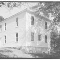
Constitution Hall, Lecompton, Kansas
-
Description
-
Photograph of Constitution Hall, site of the Lecompton Constitutional Convention on January 12, 1857. Constitution Hall was built in 1856 and restored in 1991.
-
Object Type
-
Image
-
Date
-
1933
-
-
Title
-
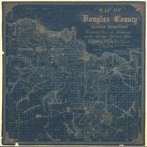
Map of Douglas County, Kansas
-
Description
-
This map of Douglas County, Kansas Territory was drawn by I. Cooper Stuck in July of 1857. The map is marked with the locations of individual people's land claims.
-
Object Type
-
Map
-
Date
-
July 1857
-

-
Title
-
Sectional Map of the Territory of Kansas
-
Description
-
This color map, entitled “Sectional Map of the Territory of Kansas,” was compiled from the field notes in the Surveyor General’s office. It was published in 1857 by John Halsall in St. Louis.
-
Object Type
-
Map
-
Date
-
1857
-

-
Title
-
Kansas and Nebraska 1856
-
Description
-
This color map, entitled “Kansas and Nebraska 1856,” was printed by J.G. Wells in New York.
-
Object Type
-
Map
-
Date
-
1856
