Error message
Notice: Trying to access array offset on value of type null in IslandoraSolrDisplayManagerResults->currentQueryDisplays() (line 222 of /var/www/drupal7/sites/all/modules/islandora_solr_display_manager/includes/islandora_solr_display_manager.inc).
-
-
Title
-
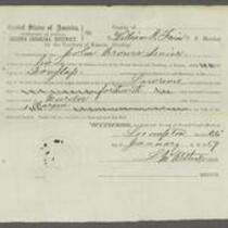
Documents Relating to Kansas Territory, U.S. District Court, 3rd District vs. James Montgomery
-
Description
-
These documents, dated between December 24, 1858 and February 17, 1859, relate to the case of Kansas Territory, U.S. District Court, 3rd District versus James Montgomery for robbery and murder. In the documents, James Montgomery, John Brown, and other men are accused of murdering John Little and robbing his store on December 16, 1858, while attempting to free their comrade Benjamin Price at Fort Scott, Kansas. The documents include a writ for the arrest of John Brown and a statement by William P. Fain, U.S. Marshal for Kansas Territory.
-
Object Type
-
Legal Document
-
Date
-
December 24, 1858-February 17, 1859
-

-
Title
-
Sectional Map of Kansas Territory
-
Description
-
This color map, dated April 1857, is entitled "Sectional Map of Kansas Territory." It was drafted by C.P. Wiggin and signed by L.A. MacLean, Chief Clerk of the Surveyor General’s office in Lecompton, Kansas Territory. MacLean certifies that the map was compiled from U.S. survey field notes. The map was published by MacLean and Lawrence and printed by William Schuchman and Bro. in Philadelphia.
-
Object Type
-
Map
-
Date
-
April 1857
-

-
Title
-
New Sectional Map of Kansas
-
Description
-
This color map, drafted in 1859 by Robert L. Ream, was published by Stevenson and Morris of St. Louis, and printed by A. Janicke and Co. of St. Louis. The map is entitled “New Sectional Map of Kansas,” and was compiled from the field notes in the Surveyor General’s office.
-
Object Type
-
Map
-
Date
-
1859
-

-
Title
-
Sectional Map of the Territory of Kansas
-
Description
-
This color map, entitled “Sectional Map of the Territory of Kansas,” was compiled from the field notes in the Surveyor General’s office. It was published in 1857 by John Halsall in St. Louis.
-
Object Type
-
Map
-
Date
-
1857
-

-
Title
-
Kansas and Nebraska 1856
-
Description
-
This color map, entitled “Kansas and Nebraska 1856,” was printed by J.G. Wells in New York.
-
Object Type
-
Map
-
Date
-
1856
-

-
Title
-
Map Showing the Progress of the Public Surveys in the Territories of Kansas and Nebraska
-
Description
-
This black-and-white map, signed by Ward B. Burnett, Surveyor General, was issued by the Surveyor General’s office in Nebraska City, Nebraska Territory on October 1, 1860. The map shows the progress of the public surveys in the territories of Kansas and Nebraska, and was produced to accompany the Surveyor General’s 1860 annual report.
-
Object Type
-
Map
-
Date
-
October 1, 1860
-

-
Title
-
Map Showing the Progress of the Public Surveys in the Territories of Kansas and Nebraska
-
Description
-
This black-and-white map, signed by Ward B. Burnett, Surveyor General, was issued by the Surveyor General’s office in Nebraska City, Nebraska Territory on October 1, 1859. The map shows the progress of the public surveys in the territories of Kansas and Nebraska, and was produced to accompany the Surveyor General’s 1859 annual report.
-
Object Type
-
Map
-
Date
-
October 1, 1859
-

-
Title
-
Map Showing the Progress of the Public Surveys in the Territories of Kansas and Nebraska
-
Description
-
This black-and-white map, signed by Ward B. Burnett, Surveyor General, was issued by the Surveyor General’s office in Nebraska City, Nebraska Territory on October 1, 1858. The map depicts the progress of the public surveys in Kansas and Nebraska in 1858, and was created to accompany the Surveyor General's report of that year. The map was printed by C.B. Graham Lithographers in Washington, DC.
-
Date
-
October 1, 1858
-

-
Title
-
Map Showing the Progress of the Public Surveys in the Territories of Kansas and Nebraska
-
Description
-
This black-and-white map, signed by J. Calhoun, Surveyor General, was issued by the Surveyor General’s office in Lecompton, Kansas Territory in October 1857. The map shows the progress of the public surveys in the territories of Kansas and Nebraska, and was produced to accompany the Surveyor General’s 1857 annual report.
-
Date
-
October 1857
