Error message
Notice: Trying to access array offset on value of type null in IslandoraSolrDisplayManagerResults->currentQueryDisplays() (line 222 of /var/www/drupal7/sites/all/modules/islandora_solr_display_manager/includes/islandora_solr_display_manager.inc).
Pages
-
-
Title
-
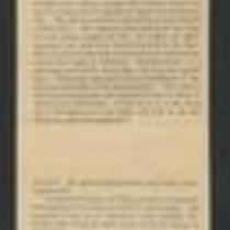
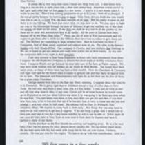
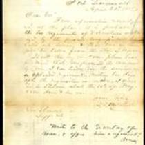
From George D. Bayard to Father
-
Description
-
This is a copy of an October 1, 1856 letter from George D. Bayard in Fort Leavenworth, Kansas to his father. Bayard tells his father that Kansas is overrun with invaders from Missouri who want to make it a slave state, and with northern emigrants who want to make it a free state. He criticizes Gov. John W. Geary for not taking a strong stand against slavery. He also mentions that troops from Lecompton are pursuing James Henry Lane and his men.
-
Date
-
October 1, 1856
-
-
Title
-
From Edward Fitch to Dear Parents
-
Description
-
In an April 28, 1861 letter to his parents in Massachusetts, Edward Fitch of Lawrence, Kansas declares, “did you think that you would ever live to see it—a Civil War, the most horrible of all wars.” He informs them that he has joined an artillery company. He adds that the military “is organising in large numbers” in Lawrence, but he expresses his fear that if Missouri secedes from the Union, Kansas will not have enough arms or ammunition for defense. He also expresses concern that the Cherokee and Choctaw tribes will fight for the South.
-
Date
-
April 28, 1861
-

-
Title
-
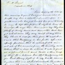
From Thomas Swords to John Dougherty
-
Description
-
This letter, dated June 25, 1856, is from Col. Thomas Swords in New York to Maj. John Dougherty. Swords expresses regret that the Kansas-Nebraska Act has resulted in conflict for Kansas Territory. He describes the Kansas-Nebraska Act as "a most just one" that "should have been carried out in the right spirit," and he voices hope that the future will bring peace to Kansas.
-
Date
-
June 25, 1856
-

-
Title
-
Sectional Map of Kansas Territory
-
Description
-
This color map, dated April 1857, is entitled "Sectional Map of Kansas Territory." It was drafted by C.P. Wiggin and signed by L.A. MacLean, Chief Clerk of the Surveyor General’s office in Lecompton, Kansas Territory. MacLean certifies that the map was compiled from U.S. survey field notes. The map was published by MacLean and Lawrence and printed by William Schuchman and Bro. in Philadelphia.
-
Object Type
-
Map
-
Date
-
April 1857
-
-
Title
-
Muster and Descriptive Roll of Recruits, Kansas, 1862-1865
-
Description
-
This military roll provides a "record of recruits, &c. rec'd, ass'g'd, and forwarded, bounty notations and casualties" in Kansas from 1862-1865. The roll lists descriptive information for each soldier, including name, age, regiment, rank, and enlistment date.
-
Date
-
1862-1865
-
-
Title
-
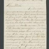
From Calvin Iserman to Brother William
-
Description
-
This letter, ca. April 1861, was sent by Calvin Iserman in Independence, Missouri, to his brother William. Calvin writes that Independence “is the strongest secession town” in Missouri. He writes that men from Independence “seized the State Arsenal” at Liberty, and Lincoln has ordered federal troops to retake it. Calvin declares that all Union supporters “who can get away” are leaving the area. The letter includes a brief note addressed to “sister Gusta,” presumably written by Calvin's wife.
-
-
Title
-
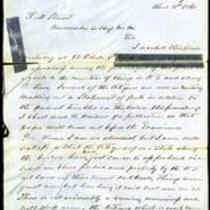
From D.B. Mitchell to Robert M. Stewart
-
Description
-
This letter was written on April 29, 1858 by D.B. Mitchell in Fort Leavenworth, Kansas, to Missouri Gov. Robert M. Stewart in Jefferson City, Missouri. Mitchell says it is likely that two regiments of Missouri volunteers will be called into service, and that one of them will be taken from the state. Mitchell writes, “Should this be the case please bear in mind that you promised the command to me. I can tender you the service of a splendid regiment within ten days after the requisition is made.”
-
Object Type
-
Letter
-
Date
-
April 29, 1858
-

-
Title
-
Nebraska and Kanzas
-
Description
-
This color map, ca. 1854-1861, is entitled “Nebraska and Kanzas.” It was printed by J.H. Colton and Co. in New York.
-
Object Type
-
Map
-
Date
-
1854-1861
-

-
Title
-
New Sectional Map of Kansas
-
Description
-
This color map, drafted in 1859 by Robert L. Ream, was published by Stevenson and Morris of St. Louis, and printed by A. Janicke and Co. of St. Louis. The map is entitled “New Sectional Map of Kansas,” and was compiled from the field notes in the Surveyor General’s office.
-
Object Type
-
Map
-
Date
-
1859
-
-
Title
-
From G.A. Parsons to Robert M. Stewart
-
Description
-
This dispatch, dated December 2, 1860, is from G.A. Parsons, Adjutant General of the Missouri Militia, to Missouri Gov. Robert M. Stewart. Parsons relays a rumor that James Montgomery has publicly stated his intention to drive his enemies out of Kansas Territory. Parsons also reports that several men from Kansas passed through Bates County, Missouri that morning and told residents about Montgomery’s attacks. “The excitement here is on the increase,” Parsons states, and he informs Stewart that “we have plenty of troops already on their way to the border.”
-
Date
-
December 2, 1860
-
-
Title
-
From Lewis A. Waterman to Dear Mother
-
Description
-
This letter, dated July 22, 1864, is from Lewis A. Waterman at Fort Leavenworth, Kansas to his mother in Providence, Rhode Island. Waterman reports that William Quantrill invaded Kansas with about 500 Bushwhackers. In retaliation, Col. Jennison crossed into Missouri with 700 troops and killed about 150 men. Waterman also tells his mother about daily life at Fort Leavenworth.
-
Date
-
July 22, 1864
-

-
Title
-
Sectional Map of the Territory of Kansas
-
Description
-
This color map, entitled “Sectional Map of the Territory of Kansas,” was compiled from the field notes in the Surveyor General’s office. It was published in 1857 by John Halsall in St. Louis.
-
Object Type
-
Map
-
Date
-
1857
-
-
Title
-
From G.A. Parsons to Robert M. Stewart
-
Description
-
This letter, dated December 2, 1860, is from G.A. Parsons, Adjutant General of the Missouri Militia, to Missouri Gov. Robert M. Stewart. Parsons informs Stewart that he has just arrived in Bates County and has found among its citizens “a good deal of uneasiness” because of recent attacks by Jayhawkers. He mentions that a citizen named Bishop was recently shot in his own house. Parsons states that he is enclosing a petition from Bates County citizens.
-
Date
-
December 2, 1860
-
-
Title
-
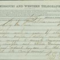
From W.E. Prince to R.T. Van Horn
-
Description
-
This telegram was sent from Capt. W.E. Prince at Fort Leavenworth, Kansas to Maj. R.T. Van Horn on August 23, 1861. Prince instructs Van Horn to "destroy everything" if forced to "abandon position." He also tells Van Horn to "continue work on gun" and to "communicate with Lexington and obtain Grahams Company ordered by me to this place."
-
Object Type
-
Telegram
-
Date
-
August 23, 1861
-
-
Title
-
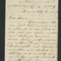
From Fred to Dear Cousins
-
Description
-
This February 28, 1862 letter is from a soldier named Fred to his cousins. He reports that he just marched from Fort Leavenworth, Kansas with Company A, to Kansas City, Missouri, where they are guarding Fort Union against the Jayhawkers. He tells his cousins that the 2nd Battalion of his regiment "had a brush with the rebels at Independence," and adds that he may be marching to St. Louis soon.
-
Date
-
February 28, 1862
-

-
Title
-
Kansas and Nebraska 1856
-
Description
-
This color map, entitled “Kansas and Nebraska 1856,” was printed by J.G. Wells in New York.
-
Object Type
-
Map
-
Date
-
1856
-
-
Title
-
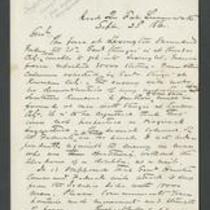
From W.E. Prince to James Henry Lane
-
Description
-
This dispatch, dated September 23, 1861, is from Capt. W.E. Prince at Fort Leavenworth, Kansas to Gen. James Henry Lane. Prince reports that the Union forces surrendered to the Missouri State Guard at the First Battle of Lexington on September 20. He also states that Gen. Sturgis expects Lane and his troops to report to Kansas City.
-
Date
-
September 23, 1861
-

-
Title
-
Map Showing the Progress of the Public Surveys in the Territories of Kansas and Nebraska
-
Description
-
This black-and-white map, signed by Ward B. Burnett, Surveyor General, was issued by the Surveyor General’s office in Nebraska City, Nebraska Territory on October 1, 1860. The map shows the progress of the public surveys in the territories of Kansas and Nebraska, and was produced to accompany the Surveyor General’s 1860 annual report.
-
Object Type
-
Map
-
Date
-
October 1, 1860
-

-
Title
-
Map Showing the Progress of the Public Surveys in the Territories of Kansas and Nebraska
-
Description
-
This black-and-white map, signed by Ward B. Burnett, Surveyor General, was issued by the Surveyor General’s office in Nebraska City, Nebraska Territory on October 1, 1859. The map shows the progress of the public surveys in the territories of Kansas and Nebraska, and was produced to accompany the Surveyor General’s 1859 annual report.
-
Object Type
-
Map
-
Date
-
October 1, 1859
-

-
Title
-
Map Showing the Progress of the Public Surveys in Kansas and Nebraska
-
Description
-
This black-and-white map, signed by Mark W. Delahay, Surveyor General, was issued by the Surveyor General’s office in Leavenworth, Kansas on September 2, 1861. The map shows the progress of the public surveys in Kansas and Nebraska, and was produced to accompany the Surveyor General’s report of 1861.
-
Object Type
-
Map
-
Date
-
September 2, 1861
Pages
