
The missouri-kansas conflict 1854-1865
Error message
Notice: Trying to access array offset on value of type null in IslandoraSolrDisplayManagerResults->currentQueryDisplays() (line 222 of /var/www/drupal7/sites/all/modules/islandora_solr_display_manager/includes/islandora_solr_display_manager.inc).


Object Type
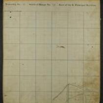
- Map (4)
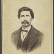
- Image (1)
- Letter (1)
- Newspaper Article (1)
Local Subject
- Bleeding Kansas, Bloodletting Missouri (7)
- Picturing the War (5)
- American Indians (4)
- Battle for Missouri, 1861-1865 -- Military History of Missouri and Kansas (4)
- Kansas military units (3)
- Surviving a Guerrilla War (3)
- African Americans (1)
- Bushwhackers (1)
- Missouri Expedition / Price's Raid (1)
- Missouri military units (Confederate) (1)
- Missouri military units (Union) (1)
- Order No. 11 (1)
- Presidential Election of 1860, Secession, and the War's Commencement (1)
- Women (1)
People
- Charles R Jennison (2)
- Samuel R Curtis (2)
- --> (1)
- Alice Trego (1)
- Edward Fitch (1)
- Edward P. Kellam (1)
- G.W. Veale (1)
- Isaac Cooper Stuck (1)
- J.Bien (Lithographer) (1)
- J.G. Wells (Lithographer) (1)
- James Henry Lane (1)
- James Montgomery (1)
- John Halsall (1)
- John W Geary (1)
- Joseph Orville Shelby (1)
- Louis A. Myers (1)
- S.G. Cato (1)
- Sterling Price (1)
- Thomas E Ewing (1)
- Tuttle's Fine Art Gallery (photographer) (1)
Geographic Subject
- Johnson County, Kansas (11)
- Douglas County, Kansas (7)
- Bourbon County, Kansas (5)
- Lawrence, Kansas (5)
- Leavenworth County, Kansas (5)
- Shawnee County, Kansas (5)
- Fort Scott, Kansas (4)
- Kansas City, Missouri (4)
- Leavenworth, Kansas (4)
- Lecompton, Kansas (4)
- Linn County, Kansas (4)
- Topeka, Kansas (4)
- Atchison County, Kansas (3)
- Doniphan County, Kansas (3)
- Fort Leavenworth, Kansas (3)
- Franklin County, Kansas (3)
- Jackson County, Missouri (3)
- Platte County, Missouri (3)
- Wyandotte County, Kansas (3)
- Atchison, Kansas (2)
- Carroll County, Missouri (2)
- Clay County, Missouri (2)
- Jefferson County, Kansas (2)
- Ray County, Missouri (2)
- Andrew County, Missouri (1)
- Atchison County, Missouri (1)
- Bates County, Missouri (1)
- Brown County, Kansas (1)
- Buchanan County, Missouri (1)
- Cass County, Missouri (1)
- Chariton County, Missouri (1)
- Dekalb County, Missouri (1)
- Harrison County, Missouri (1)
- Henry County, Missoui (1)
- Holt County, Missouri (1)
- Independence, Missouri (1)
- Jackson County, Kansas (1)
- Johnson County, Missouri (1)
- Linn County, Missouri (1)
- Mercer County, Missouri (1)
- Miami County, Kansas (1)
- Nodaway County, Missouri (1)
- Osage County, Kansas (1)
- Shawnee Indian Mission, Kansas (1)
- St. Joseph, Missouri (1)
- Vernon County, Missouri (1)
- Weston, Missouri (1)