Error message
Notice: Trying to access array offset on value of type null in IslandoraSolrDisplayManagerResults->currentQueryDisplays() (line 222 of /var/www/drupal7/sites/all/modules/islandora_solr_display_manager/includes/islandora_solr_display_manager.inc).
-
-
Title
-
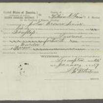
Documents Relating to Kansas Territory, U.S. District Court, 3rd District vs. James Montgomery
-
Description
-
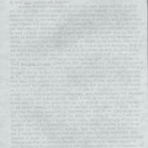
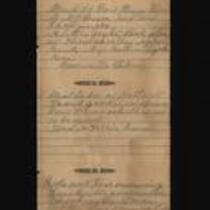
These documents, dated between December 24, 1858 and February 17, 1859, relate to the case of Kansas Territory, U.S. District Court, 3rd District versus James Montgomery for robbery and murder. In the documents, James Montgomery, John Brown, and other men are accused of murdering John Little and robbing his store on December 16, 1858, while attempting to free their comrade Benjamin Price at Fort Scott, Kansas. The documents include a writ for the arrest of John Brown and a statement by William P. Fain, U.S. Marshal for Kansas Territory.
-
Object Type
-
Legal Document
-
Date
-
December 24, 1858-February 17, 1859
-
-
Title
-
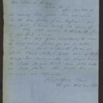
From The Few That Are Left to John W. Geary
-
Description
-
This letter to Kansas Gov. John W. Geary is dated September 18, 1856 and signed by “The few that are left.” The letter asks Geary to send troops to protect the citizens of Cass County, Missouri; Sugar Mound, Kansas; and Fort Scott, Kansas. “This section of the country has just been ravaged by the war parties from Missouri,” the letter says. “The people here are unarmed and defenseless.”
-
Date
-
September 18, 1856
-
-
Title
-
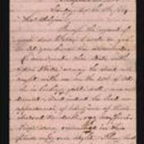
From Maurice E. Pitcher to Mr. Colgan
-
Description
-
On November 6, 1864, Maurice E. Pitcher writes from Independence, Missouri to Mr. Colgan. Pitcher states that he saw Colgan's son Willie on October 21 when he came into Missouri with Gen. Price's army: "he is looking quite well…he had no appearance of being 'one of Price's starved to death, rag-muffins.'" He says that Price's men "had a series of battles from little blue (in this county) until within a few miles of Fort Scott, and you may well imagine they had a series of successes."
-
Date
-
November 6, 1864
-
-
Title
-
Medical Record of Examination of Recruits
-
Description
-
This is a bound volume of records noting the medical examinations of men recruited to the Union Army in Kansas. The records, dating from November 5, 1864 to April 20, 1865, include the recruits' names, ages, country or state of birth, occupation, height, complexion, eye and hair color, chest measurements, race, and town or county of residence.
-
Date
-
November 5, 1864-April 20, 1865
-
-
Title
-
From Florella Brown Adair to Samuel Lyle Adair and Emma Adair
-
Description
-
This letter, dated November 21, 1860, was written by Florella Brown Adair in Hudson, Ohio to her husband Samuel Lyle Adair and daughter Emma in Osawatomie, Kansas. Florella responds to their recent letters, which were “so complaining and discouraging, that I feel more like staying away, than hurrying home…it seems to me that the Territory is cursed of the Lord and that it is fighting against him to try to live there and do anything but barely to exist…I cannot help feeling a perfect disgust for Kansas life, and most of Kansas people.” Florella adds that she read about the “Montgomery and Fort Scott troubles” in the newspapers.
-
Object Type
-
Letter
-
Date
-
November 21, 1860
-
-
Title
-
Diary of Dr. J.H.P. Baker
-
Description
-
This is an excerpt from the diary of Dr. J.H.P. Baker, an army doctor working under the command of Gen. Joseph O. Shelby. The entries included here are from October 10-27, 1864. Baker discusses conscription, bushwhackers, travelling across Missouri, and marching to Price’s headquarters. He mentions the Battle of Boonville, the Second Battle of Lexington, the Battle of the Big Blue, the Second Battle of Independence, the Battle of Westport, and the Battle of Cedar Creek.
-
Object Type
-
Diary
-
Date
-
October 10, 1864-October 27, 1864
-

-
Title
-
Sectional Map of Kansas Territory
-
Description
-
This color map, dated April 1857, is entitled "Sectional Map of Kansas Territory." It was drafted by C.P. Wiggin and signed by L.A. MacLean, Chief Clerk of the Surveyor General’s office in Lecompton, Kansas Territory. MacLean certifies that the map was compiled from U.S. survey field notes. The map was published by MacLean and Lawrence and printed by William Schuchman and Bro. in Philadelphia.
-
Object Type
-
Map
-
Date
-
April 1857
-

-
Title
-
New Sectional Map of Kansas
-
Description
-
This color map, drafted in 1859 by Robert L. Ream, was published by Stevenson and Morris of St. Louis, and printed by A. Janicke and Co. of St. Louis. The map is entitled “New Sectional Map of Kansas,” and was compiled from the field notes in the Surveyor General’s office.
-
Object Type
-
Map
-
Date
-
1859
-

-
Title
-
From A.J. Sexton to Catherine
-
Description
-
A.J. Sexton writes a letter from Leavenworth, Kansas to his wife Catherine in Wisconsin on February 26, 1862. Sexton, a member of the 12th Regiment of Wisconsin Infantry Volunteers, describes daily life at Fort Leavenworth, where his company is headquartered. He also announces that the city of Nashville recently surrendered to the Union and “the general opinion is that the war will soon close.”
-
Date
-
February 26, 1862
-

-
Title
-
Sectional Map of the Territory of Kansas
-
Description
-
This color map, entitled “Sectional Map of the Territory of Kansas,” was compiled from the field notes in the Surveyor General’s office. It was published in 1857 by John Halsall in St. Louis.
-
Object Type
-
Map
-
Date
-
1857
-

-
Title
-
Kansas and Nebraska 1856
-
Description
-
This color map, entitled “Kansas and Nebraska 1856,” was printed by J.G. Wells in New York.
-
Object Type
-
Map
-
Date
-
1856
-

-
Title
-
Map Showing the Progress of the Public Surveys in the Territories of Kansas and Nebraska
-
Description
-
This black-and-white map, signed by Ward B. Burnett, Surveyor General, was issued by the Surveyor General’s office in Nebraska City, Nebraska Territory on October 1, 1860. The map shows the progress of the public surveys in the territories of Kansas and Nebraska, and was produced to accompany the Surveyor General’s 1860 annual report.
-
Object Type
-
Map
-
Date
-
October 1, 1860
-

-
Title
-
Map Showing the Progress of the Public Surveys in the Territories of Kansas and Nebraska
-
Description
-
This black-and-white map, signed by Ward B. Burnett, Surveyor General, was issued by the Surveyor General’s office in Nebraska City, Nebraska Territory on October 1, 1859. The map shows the progress of the public surveys in the territories of Kansas and Nebraska, and was produced to accompany the Surveyor General’s 1859 annual report.
-
Object Type
-
Map
-
Date
-
October 1, 1859
-

-
Title
-
Map Showing the Progress of the Public Surveys in the Territories of Kansas and Nebraska
-
Description
-
This black-and-white map, signed by Ward B. Burnett, Surveyor General, was issued by the Surveyor General’s office in Nebraska City, Nebraska Territory on October 1, 1858. The map depicts the progress of the public surveys in Kansas and Nebraska in 1858, and was created to accompany the Surveyor General's report of that year. The map was printed by C.B. Graham Lithographers in Washington, DC.
-
Date
-
October 1, 1858
-

-
Title
-
Map Showing the Progress of the Public Surveys in the Territories of Kansas and Nebraska
-
Description
-
This black-and-white map, signed by J. Calhoun, Surveyor General, was issued by the Surveyor General’s office in Lecompton, Kansas Territory in October 1857. The map shows the progress of the public surveys in the territories of Kansas and Nebraska, and was produced to accompany the Surveyor General’s 1857 annual report.
-
Date
-
October 1857
