Error message
Notice: Trying to access array offset on value of type null in IslandoraSolrDisplayManagerResults->currentQueryDisplays() (line 222 of /var/www/drupal7/sites/all/modules/islandora_solr_display_manager/includes/islandora_solr_display_manager.inc).
-
-
Title
-
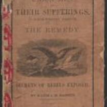
Union Men and Their Sufferings in North-Western Missouri
-
Description
-
This 1864 pamphlet, entitled “Union Men and Their Sufferings in North-Western Missouri,” was written by Major J.M. Bassett, former Provost Marshal-General of the Northwest District of Missouri. Bassett provides a “glance at the history of the Rebellion in Northwest Missouri,” admitting “it may be that my hatred for rebels is too intense, my sympathy for loyal men too strong, to make every sentence I write acceptable to all.” The pamphlet, which features several black-and-white illustrations, was published by the Press of Wynkcop, Hallenbeck, and Thomas in New York, with proceeds from its sale given to The Ladies’ Aid Society of St. Joseph, Missouri.
-
Date
-
1864
-
-
Title
-
Wyllys C. Ransom vs. George C. Bingham
-
Description
-
These documents, created between 1866 and 1867, relate to the Jackson County, Missouri court case Wyllys C. Ransom vs. George C. Bingham. Ransom accuses Bingham of slander, asserting that Bingham publicly and repeatedly said he was a “murderer, robber, thief and a house burner” during the Civil War. Portions of testimony are from Ransom’s fellow officers in the Kansas Volunteers. Ransom seeks $30,000 in damages.
-
Object Type
-
Legal Document
-
Date
-
1866-1867
-

-
Title
-
Sectional Map of Kansas Territory
-
Description
-
This color map, dated April 1857, is entitled "Sectional Map of Kansas Territory." It was drafted by C.P. Wiggin and signed by L.A. MacLean, Chief Clerk of the Surveyor General’s office in Lecompton, Kansas Territory. MacLean certifies that the map was compiled from U.S. survey field notes. The map was published by MacLean and Lawrence and printed by William Schuchman and Bro. in Philadelphia.
-
Object Type
-
Map
-
Date
-
April 1857
-
-
Title
-
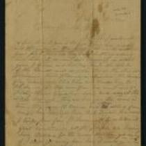
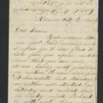
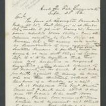
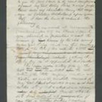
From Calvin Iserman to Brother William
-
Description
-
This letter, ca. April 1861, was sent by Calvin Iserman in Independence, Missouri, to his brother William. Calvin writes that Independence “is the strongest secession town” in Missouri. He writes that men from Independence “seized the State Arsenal” at Liberty, and Lincoln has ordered federal troops to retake it. Calvin declares that all Union supporters “who can get away” are leaving the area. The letter includes a brief note addressed to “sister Gusta,” presumably written by Calvin's wife.
-

-
Title
-
Nebraska and Kanzas
-
Description
-
This color map, ca. 1854-1861, is entitled “Nebraska and Kanzas.” It was printed by J.H. Colton and Co. in New York.
-
Object Type
-
Map
-
Date
-
1854-1861
-

-
Title
-
New Sectional Map of Kansas
-
Description
-
This color map, drafted in 1859 by Robert L. Ream, was published by Stevenson and Morris of St. Louis, and printed by A. Janicke and Co. of St. Louis. The map is entitled “New Sectional Map of Kansas,” and was compiled from the field notes in the Surveyor General’s office.
-
Object Type
-
Map
-
Date
-
1859
-
-
Title
-
From Fred to Dear Cousins
-
Description
-
This February 28, 1862 letter is from a soldier named Fred to his cousins. He reports that he just marched from Fort Leavenworth, Kansas with Company A, to Kansas City, Missouri, where they are guarding Fort Union against the Jayhawkers. He tells his cousins that the 2nd Battalion of his regiment "had a brush with the rebels at Independence," and adds that he may be marching to St. Louis soon.
-
Date
-
February 28, 1862
-
-
Title
-
From W.E. Prince to James Henry Lane
-
Description
-
This dispatch, dated September 23, 1861, is from Capt. W.E. Prince at Fort Leavenworth, Kansas to Gen. James Henry Lane. Prince reports that the Union forces surrendered to the Missouri State Guard at the First Battle of Lexington on September 20. He also states that Gen. Sturgis expects Lane and his troops to report to Kansas City.
-
Date
-
September 23, 1861
-

-
Title
-
Map Showing the Progress of the Public Surveys in the Territories of Kansas and Nebraska
-
Description
-
This black-and-white map, signed by Ward B. Burnett, Surveyor General, was issued by the Surveyor General’s office in Nebraska City, Nebraska Territory on October 1, 1860. The map shows the progress of the public surveys in the territories of Kansas and Nebraska, and was produced to accompany the Surveyor General’s 1860 annual report.
-
Object Type
-
Map
-
Date
-
October 1, 1860
-

-
Title
-
Map Showing the Progress of the Public Surveys in the Territories of Kansas and Nebraska
-
Description
-
This black-and-white map, signed by Ward B. Burnett, Surveyor General, was issued by the Surveyor General’s office in Nebraska City, Nebraska Territory on October 1, 1859. The map shows the progress of the public surveys in the territories of Kansas and Nebraska, and was produced to accompany the Surveyor General’s 1859 annual report.
-
Object Type
-
Map
-
Date
-
October 1, 1859
-

-
Title
-
Map Showing the Progress of the Public Surveys in Kansas and Nebraska
-
Description
-
This black-and-white map, signed by Mark W. Delahay, Surveyor General, was issued by the Surveyor General’s office in Leavenworth, Kansas on September 2, 1861. The map shows the progress of the public surveys in Kansas and Nebraska, and was produced to accompany the Surveyor General’s report of 1861.
-
Object Type
-
Map
-
Date
-
September 2, 1861
-
-
Title
-
Report on Price's Raid
-
Description
-
James Henry Lane wrote this report ca. October 1864 about his role in the campaign against Price's Raid. Lane states that he accompanied Gen. Blunt, Col. Moonlight, Col. Jennison, and Gen. Curtis on an expedition into Missouri to impede Sterling Price and his forces. Lane describes the Second Battle of Lexington, the Second Battle of Independence, the Battle of Byram's Ford, the Battle of Westport, and the Battle of Little Blue River.
-

-
Title
-
Map Showing the Progress of the Public Surveys in the Territories of Kansas and Nebraska
-
Description
-
This black-and-white map, signed by J. Calhoun, Surveyor General, was issued by the Surveyor General’s office in Lecompton, Kansas Territory in October 1857. The map shows the progress of the public surveys in the territories of Kansas and Nebraska, and was produced to accompany the Surveyor General’s 1857 annual report.
-
Date
-
October 1857
