Error message
Notice: Trying to access array offset on value of type null in IslandoraSolrDisplayManagerResults->currentQueryDisplays() (line 222 of /var/www/drupal7/sites/all/modules/islandora_solr_display_manager/includes/islandora_solr_display_manager.inc).
-
-
Title
-
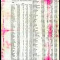
1860 Missouri Census Table
-
Description
-
This ca. 1860 printed document presents the results of the 1860 Missouri census, showing the population of whites, “free colored” and slaves in each county. The table lists the total state population as 1,182,012, with 1,063,599 whites, 3,572 Free Colored, and 114,931 slaves. Lafayette County has the largest slave population with 6,374 slaves. The table also reveals a small American Indian population in Gasconade and Jackson Counties.
-
Object Type
-
Government Document
-
-
Title
-
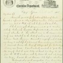
From Thomas Fletcher to R.T. Van Horn
-
Description
-
This dispatch, dated October 20, 1866, is from Thomas Fletcher in Jefferson City, Missouri to Hon. R.T. Van Horn. Fletcher reports that his plans concerning troop movements within Missouri have changed. He had originally planned to send troops to Platte, Clay, Carroll, Ray, and Chariton counties, but is now occupied with political concerns: "The ablest men in the Conservative Party are detailed to the duty of getting up a disturbance between Genls Sherman[,] Hancock & myself, and it keeps me busy & watchful to prevent them making us trouble."
-
Date
-
October 20, 1866
-

-
Title
-
Kansas and Nebraska 1856
-
Description
-
This color map, entitled “Kansas and Nebraska 1856,” was printed by J.G. Wells in New York.
-
Object Type
-
Map
-
Date
-
1856
