Error message
Notice: Trying to access array offset on value of type null in IslandoraSolrDisplayManagerResults->currentQueryDisplays() (line 222 of /var/www/drupal7/sites/all/modules/islandora_solr_display_manager/includes/islandora_solr_display_manager.inc).
-
-
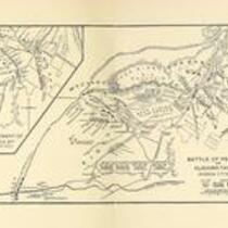
Title
-
Battle of Pea Ridge
-
Description
-
This map of the Battle of Pea Ridge was originally published in Abraham Lincoln: A History, Vol. V, by John G. Nicolay and John Hay.
-
Object Type
-
Map
-
Date
-
n.d.
-
-
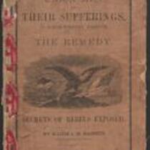
Title
-
Union Men and Their Sufferings in North-Western Missouri
-
Description
-
This 1864 pamphlet, entitled “Union Men and Their Sufferings in North-Western Missouri,” was written by Major J.M. Bassett, former Provost Marshal-General of the Northwest District of Missouri. Bassett provides a “glance at the history of the Rebellion in Northwest Missouri,” admitting “it may be that my hatred for rebels is too intense, my sympathy for loyal men too strong, to make every sentence I write acceptable to all.” The pamphlet, which features several black-and-white illustrations, was published by the Press of Wynkcop, Hallenbeck, and Thomas in New York, with proceeds from its sale given to The Ladies’ Aid Society of St. Joseph, Missouri.
-
Date
-
1864
-

-
Title
-
Fort Davidson
-
Description
-
Modern view of Fort Davidson, where Gen. Thomas Ewing battled with Sterling Price and his Army of Missouri. The crater is still visible on the right side of the photograph, and Pilot Knob can be seen in the background.
-
Date
-
September 30, 2006
-
-
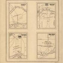
Title
-
Battlegrounds of Price's Raid
-
Description
-
Maps of the battlefields at "Mine Creek, Oct. 22d 64," "Westport, Oct. 23d 64" "Charlot, Oct. 25th 64," and "Newtonia, Nov. 4th 64," showing the positions of troops, roads, drainage, a few houses, and relief by hachures. Charlot refers to "Charlot's Farm" near Richards, MO. This event is better known as the Battle of the Marmaton River. The Battle of Mine Creek took place south of Pleasanton, KS.
-
Date
-
1865
-
-
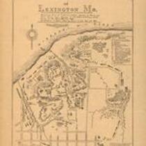
Title
-
Battle field of Lexington
-
Description
-
Battle field of Lexington, Mo., showing plan of earthwork defended by Federal and State troops under command of Col. James A. Mulligan, U.S.A. during the 18th, 19th and 20th Sept. 1861. Surrendered to Genl. Sterling Price, C.S.A., Sept. 20th 1861. This map Shows fortifications, troop positions, vegetation, drainage, streets, and relief by hachures and spot heights. Important sites are listed in the legend and keyed to the map by letters.
-
Date
-
1870-1879
