Error message
Notice: Trying to access array offset on value of type null in IslandoraSolrDisplayManagerResults->currentQueryDisplays() (line 222 of /var/www/drupal7/sites/all/modules/islandora_solr_display_manager/includes/islandora_solr_display_manager.inc).
-
-
Title
-
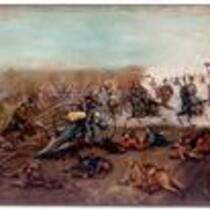
Battle of the Big Blue
-
Description
-
Benjamin D. Mileham painting of the Battle of the Big Blue, which occurred in Jackson County, Missouri, on October 22, 1864.
-
Object Type
-
Image
-
Date
-
1896
-
-
Title
-
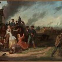
Martial Law or Order No. 11
-
Description
-
Depiction of Order No. 11, which was issued by Union General Thomas E. Ewing at the District of the Border Headquarters in Kansas City, Missouri on August 25, 1863. The order commanded residents of Jackson, Cass, Bates, and northern Vernon counties to leave their homes and move away from the area within fifteen days. Ewing issued the directive four days after Quantrill’s Raid on Lawrence, in an attempt to suppress guerrilla violence.
-
Object Type
-
Image
-
Date
-
1868
-
-
Title
-
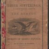
Union Men and Their Sufferings in North-Western Missouri
-
Description
-
This 1864 pamphlet, entitled “Union Men and Their Sufferings in North-Western Missouri,” was written by Major J.M. Bassett, former Provost Marshal-General of the Northwest District of Missouri. Bassett provides a “glance at the history of the Rebellion in Northwest Missouri,” admitting “it may be that my hatred for rebels is too intense, my sympathy for loyal men too strong, to make every sentence I write acceptable to all.” The pamphlet, which features several black-and-white illustrations, was published by the Press of Wynkcop, Hallenbeck, and Thomas in New York, with proceeds from its sale given to The Ladies’ Aid Society of St. Joseph, Missouri.
-
Date
-
1864
-

-
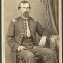
Title
-
Soldier, Eleventh Kansas Volunteer Cavalry
-
Description
-
This sepia carte de visite, ca. 1861-1865, depicts an unidentified soldier who served in the Eleventh Kansas Volunteer Cavalry. The carte de visite was produced by S.M. Eby & Son in Kansas City, Missouri. Carte de visites were small photographs that were often used as calling cards and became very popular during the Civil War.
-
Object Type
-
Image
-
-
Title
-
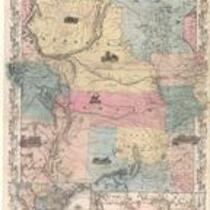
Nebraska and Kansas
-
Description
-
This color map, entitled “Nebraska and Kansas,” shows those two territories, the territory acquired from Mexico in 1854, and a small map of the continental United States. The map was published in 1854 by J.H. Colton and Co. in New York.
-
Object Type
-
Map
-
Date
-
1854
-
-
Title
-
Soldier, Eleventh Kansas Volunteer Cavalry
-
Description
-
This sepia carte de visite, ca. 1861-1865, depicts an unidentified soldier who served in the Eleventh Kansas Volunteer Cavalry. The carte de visite was produced by G. Wertz's company, Photograph Rooms, in Kansas City, Missouri. Carte de visites were small photographs that were often used as calling cards and became very popular during the Civil War.
-
Object Type
-
Image
-

-
Title
-
Sectional Map of Kansas Territory
-
Description
-
This color map, dated April 1857, is entitled "Sectional Map of Kansas Territory." It was drafted by C.P. Wiggin and signed by L.A. MacLean, Chief Clerk of the Surveyor General’s office in Lecompton, Kansas Territory. MacLean certifies that the map was compiled from U.S. survey field notes. The map was published by MacLean and Lawrence and printed by William Schuchman and Bro. in Philadelphia.
-
Object Type
-
Map
-
Date
-
April 1857
-

-
Title
-
Nebraska and Kanzas
-
Description
-
This color map, ca. 1854-1861, is entitled “Nebraska and Kanzas.” It was printed by J.H. Colton and Co. in New York.
-
Object Type
-
Map
-
Date
-
1854-1861
-

-
Title
-
New Sectional Map of Kansas
-
Description
-
This color map, drafted in 1859 by Robert L. Ream, was published by Stevenson and Morris of St. Louis, and printed by A. Janicke and Co. of St. Louis. The map is entitled “New Sectional Map of Kansas,” and was compiled from the field notes in the Surveyor General’s office.
-
Object Type
-
Map
-
Date
-
1859
-

-
Title
-
Map Showing the Progress of the Public Surveys in the Territories of Kansas and Nebraska
-
Description
-
This black-and-white map, signed by Ward B. Burnett, Surveyor General, was issued by the Surveyor General’s office in Nebraska City, Nebraska Territory on October 1, 1860. The map shows the progress of the public surveys in the territories of Kansas and Nebraska, and was produced to accompany the Surveyor General’s 1860 annual report.
-
Object Type
-
Map
-
Date
-
October 1, 1860
-

-
Title
-
Map Showing the Progress of the Public Surveys in the Territories of Kansas and Nebraska
-
Description
-
This black-and-white map, signed by Ward B. Burnett, Surveyor General, was issued by the Surveyor General’s office in Nebraska City, Nebraska Territory on October 1, 1859. The map shows the progress of the public surveys in the territories of Kansas and Nebraska, and was produced to accompany the Surveyor General’s 1859 annual report.
-
Object Type
-
Map
-
Date
-
October 1, 1859
-

-
Title
-
Map Showing the Progress of the Public Surveys in Kansas and Nebraska
-
Description
-
This black-and-white map, signed by Mark W. Delahay, Surveyor General, was issued by the Surveyor General’s office in Leavenworth, Kansas on September 2, 1861. The map shows the progress of the public surveys in Kansas and Nebraska, and was produced to accompany the Surveyor General’s report of 1861.
-
Object Type
-
Map
-
Date
-
September 2, 1861
-

-
Title
-
Map Showing the Progress of the Public Surveys in the Territories of Kansas and Nebraska
-
Description
-
This black-and-white map, signed by J. Calhoun, Surveyor General, was issued by the Surveyor General’s office in Lecompton, Kansas Territory in October 1857. The map shows the progress of the public surveys in the territories of Kansas and Nebraska, and was produced to accompany the Surveyor General’s 1857 annual report.
-
Date
-
October 1857
