Error message
Notice: Trying to access array offset on value of type null in IslandoraSolrDisplayManagerResults->currentQueryDisplays() (line 222 of /var/www/drupal7/sites/all/modules/islandora_solr_display_manager/includes/islandora_solr_display_manager.inc).
-
-
Title
-
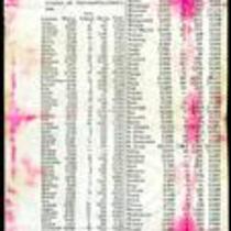
1860 Missouri Census Table
-
Description
-
This ca. 1860 printed document presents the results of the 1860 Missouri census, showing the population of whites, “free colored” and slaves in each county. The table lists the total state population as 1,182,012, with 1,063,599 whites, 3,572 Free Colored, and 114,931 slaves. Lafayette County has the largest slave population with 6,374 slaves. The table also reveals a small American Indian population in Gasconade and Jackson Counties.
-
Object Type
-
Government Document
-
-
Title
-
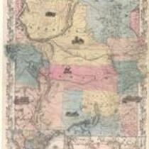
Nebraska and Kansas
-
Description
-
This color map, entitled “Nebraska and Kansas,” shows those two territories, the territory acquired from Mexico in 1854, and a small map of the continental United States. The map was published in 1854 by J.H. Colton and Co. in New York.
-
Object Type
-
Map
-
Date
-
1854
-

-
Title
-
Kansas and Nebraska 1856
-
Description
-
This color map, entitled “Kansas and Nebraska 1856,” was printed by J.G. Wells in New York.
-
Object Type
-
Map
-
Date
-
1856
