Error message
Notice: Trying to access array offset on value of type null in IslandoraSolrDisplayManagerResults->currentQueryDisplays() (line 222 of /var/www/drupal7/sites/all/modules/islandora_solr_display_manager/includes/islandora_solr_display_manager.inc).
-
-
Title
-
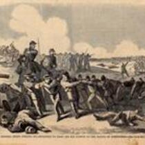
Battle of Wilson's Creek
-
Description
-
This sketch, originally published in Harper's Weekly on August 31, 1861, depicts the Union retreat at the end of the Battle of Wilson's Creek on August 10, 1861, after Nathaniel Lyon's death and after Sigel's horses had been killed. The caption states: "General Siegel forcing his prisoners [Confederate and Native American] to draw off his cannon at the Battle of Springfield." Although Harper's Weekly describes this as the Battle of Springfield, this conflict has come to be known as the Battle of Wilson's Creek. The next skirmish in the area, Zagonyi's Charge, occured near Springfield, Missouri on October 25, 1861.
-
Object Type
-
Image
-
Date
-
August 31, 1861
-

-
Title
-
Map Showing the Progress of the Public Surveys in Kansas and Nebraska
-
Description
-
This black-and-white map, signed by Mark W. Delahay, Surveyor General, was issued by the Surveyor General’s office in Leavenworth, Kansas on September 2, 1861. The map shows the progress of the public surveys in Kansas and Nebraska, and was produced to accompany the Surveyor General’s report of 1861.
-
Object Type
-
Map
-
Date
-
September 2, 1861
